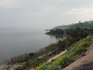
The Galilee is a wonderful place. You have probably read the statistics... 33 miles around, 13 miles long, 8 miles wide and about 140 feet deep at it's deepest. It has the lowest elevation of any fresh water lake on earth at about 700 ft. below sea level. Beyond the dry statistics it is one of the lovely places on earth and a place beloved of the Savior and the focus of much of his missionary labors. The ancient highway of nations, the Via Maris, put the Galilee in the crosshairs of ancient human civilization. By working in the Galilee, Jesus had access to the melting pot of his time. This view is from Boat Museum, looking east towards Capernaum and Jordan/Syria.
One thing that has bugged me since my first visits in 2000, are all the paintings that show Jesus walking on a sandy shore. The photo at left is typical of all the shoreline around the sea. #1. The Sea of Galilee is part of the Great Rift Valley. #2. Notice the dark rock.... black Basalt. When we get to Capernaum and other ruins you will see most of the buildings are of black basalt. The towns have a dark, rather gloomy appearance. I much prefer the white limestone of Jerusalem for building material. Main point.... lots of rock! no sand (unless they have started trucking it in).
Here is another section of shore line. Mustard grows everywhere. The view across the Sea was actually fairly clear that day.
This is looking west towards Tiberius. Tiberius was a Roman city at the time of Christ, but He seems to have spent little time there. The faint, almost shadow hills on the other side are the hills of Jordan. I should talk about water... Water is such a huge issue in this area. The 1967 war was at least in part fought because Syria tried to divert water from Galilee. Angst is had by Jordanians and Syrians because Israel pipes water to all the major cities of Israel from Galilee, but will not share with them. Jordan has diverted the Yarmouk River, because Israel will not share. The Sea of Galilee has lost water. The Jordan River, which used to be mighty is barely a stream.


